Tag Archives: hiking

Hit the Trails

by Adam Brown

A guide to exploring Bozeman’s sprawling network of trails.

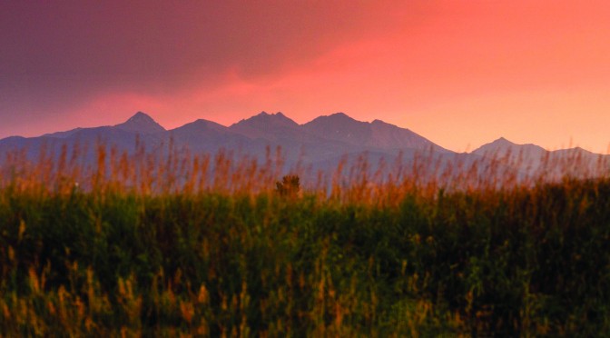
Next time you get a chance—a quiet moment under the big, blue Montana sky—take a second to look around. What do you see? First, you’ll probably notice the Bridger Range, cradling our town from the northeast. To the south, the Gallatin Range extends far back into the skyline. Southwest, the Spanish Peaks poke up, keeping the Madison Range out of view and ready to be uncovered. Due west and farther out, oftentimes fading into the horizon on hazier days, the Tobacco Roots loom in the distance. The Absarokas sit just out of view to the east, with no shortage of stones to turn.

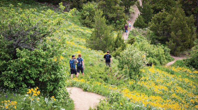
There are more ranges to see, of course, depending on one’s particular perch. But the point is, there are foothills, peaks, canyons, and valleys in every direction. Nearly every summit can be climbed; every drainage holds a secret. Even the foothills and woods near town abound with opportunity—the amount of adventures and experiences you can have is limited only by your desire to peek around that next bend. The best part? Trails wind their way through it all, beckoning you to come forth and explore. If you need some advice to get started, here are a few classic outings.

Around Town
Gallagator: Named after an old railway line, this trail acts like an arterial pipeline through Bozeman. It’s a popular commuter path from the north to the south end of town. On it, you’ll stroll by gardens, climbing boulders, and plenty of jumping-off points onto other local trails.

East Gallatin Recreation Area: North of town, you’ll find this local hotspot. Despite its close proximity and popularity, there is plenty to do here. Get in on the action at East Gallatin Pond (“Bozeman Beach” to the locals) or duck back into a trail system hidden among the river and trees. It, too, ties into other trails, including the path to the M.

Highland Glen Nature Preserve: This small network is another great close-to-town option. Here you’ll enjoy rolling hills, forested gulches, great views of the surrounding mountains above the lush vegetation, and the occasional company of grazing cattle.

Headin’ Up
Triple Tree: A local favorite in the foothills of the Gallatin Range. Get there using one of the nearby parking areas, or hike in from Painted Hills if you want to add some extra mileage. Otherwise, you’ll be getting about four miles of pleasant, forested trail with a great overlook back north over the valley. Be aware of mountain bikers on this trail, typically riding the loop counterclockwise.

The M: Montanans sure do love putting letters on their mountains. While some denote the town below or name of the mountain, our M is dedicated to Montana State University and goes back all the way to 1915. There are two ways to get up to the M. The standard route switchbacks along the foothills, while the steep route cuts straight up the face of the mountain. There’s a reason this hike is so popular: the view across town and the valley beyond is fantastic.

Drinking Horse: This mountain got its name because it resembles a horse taking a drink from a creek, when gazed upon from the east. The trail is another favorite of folks looking to get out for a jaunt close by, any time of year. In fact, the trail averages about 150 daily users in the winter and a whopping 500 in the summer. You may not get much solitude here, but the views toward the Bangtails and back into Bridger Canyon are remarkable.

Top Notch
Chestnut Mountain: A great summit option without having to go very far. You’ll find the trailhead just inside the mouth of the Bozeman Pass, on the way to Livingston—take the Trail Creek exit. Climb up a nicely buffed-out trail that switchbacks through forest and meadows until you’re finally rewarded with incredible views of the Absarokas and Paradise Valley.

Sacajawea Peak: One of the best bangs for your buck in the Bridgers (with Baldy a close second). Starting at Fairy Lake, this trail is only about four miles round-trip, but you’ll surely feel the elevation as you climb 2,000 vertical feet to the summit. At the top, you’ll get 360-degree views, including all the aforementioned ranges. The resident mountain goats have it good.

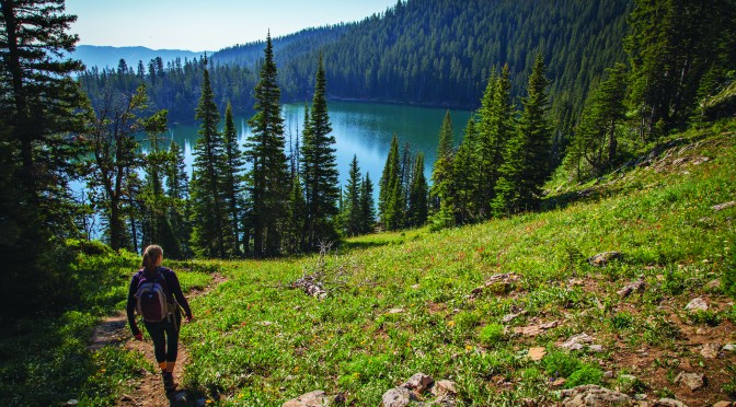
Mt. Blackmore: This mountain has a prominent presence over the valley, constantly peering down on us from the top of the Gallatin Range. Just take a gander south and you’ll be able to make out its pyramid shape. Because of its physical and historical significance to the area, it’s well worth checking out up-close and personal. From the lower trailhead, four miles round-trip will get you to Blackmore Lake, and 12 will take you all the way to the summit and back.

Etiquette
Most of the above trails are shared with bikers—even some of the more challenging ones, like Blackmore. Generally, bikers should yield to hikers, and both should yield to horses. Downhill traffic should also yield to those coming uphill. However, this is only a rough guideline, and a more nuanced approach should be taken. Just be kind, courteous, and keep your head up—everything should work out fine. It’s often much easier for a hiker or runner to take a step off the trail and allow fast-moving bikes to pass than it is to insist otherwise.

Events
May
Spring Cleanup – Hyalite Canyon. After a long winter, Hyalite needs some love. Pitch in for a morning of bagging trash and tidying trailheads. hyalite.org

May-June
GVLT Discovery Walks – Bozeman. Meet new people and make new friends on these one-hour guided walks along the Main Street to the Mountains trail system. 80+ miles await, all of which are right here, in and around town. gvlt.org 

May-September
Wind Drinkers Fun Runs – Bozeman. If you’re looking to ramp up the pace a bit and get into trail running, join the Wind Drinkers for some casual summer jaunts. winddrinkers.org

June
Summer Trails Challenge – Hit the trails and earn money for GVLT’s trail work and conservation initiatives. gvlt.org

June-August
L&C Caverns Guided Hikes – Whitehall. Explore the drier climes west of Bozeman at Lewis & Clark Caverns State Park, where guides offer an immersive hike through the sagebrush hills. fwp.mt.gov

June 1
National Trails Day – Bozeman. This is the best day to give back to the trails that give us so much. Almost every trail-related nonprofit in town has a work day scheduled, so you’ll have plenty of options to choose from. gvlt.org 

September 28
National Public Lands Day – Bozeman. Around here, we use public lands all the time, which means they need a little love and care every year. Use this last Saturday of the month to go for a hike, do some trail maintenance, or find a new trail run. gvlt.org

Editor’s note: dates are subject to change based on weather and other factors. For the most updated information, visit outsidebozeman.com/events.

Run to the Hills

Lace ‘Em Up

by Corey Hockett

Bozeman-area trails are a treasure, no matter where you come from. Like a spider web from city center, hundreds of miles of dirt paths lie at our fingertips—we only need to hop on and take off. Our town’s trustworthy trail whisperer—the Gallatin Valley Land Trust—manages 80 miles (and counting) of foot and bike routes, connecting in-town locations to deep wilderness settings. There are options for all seasons and all inclinations, so no matter your passion, Bozeman’s got you covered. 

If you’re new—and we won’t judge—you’ve got a lot to learn. But even more importantly, you’ve got a lot to explore. One of the best things about being in Bozeman is that you’re likely never further than 10 minutes from the nearest trail. Once you get ‘em mapped out, you’ll be commuting to work, biking at lunch, and going on ridge runs at sunset. And believe us, it’s just as great as it sounds.

In Town
The Gallagator
Every good town has a trail that runs through the heart of it, and the Gallagator is Bozeman’s. Named after an old railway line, the Gallagator is one of our finest commuter trails. Located on the east side of town, with access to both the top and bottom of Peets Hill, this path will take you from downtown through Langhor Park and up to campus. Along the way, you’ll pass community gardens, a climbing boulder, and many a smiling citizen.

East Gallatin Rec Area
On the north side of town, the East Gallatin Rec Area offers a web of trails and amenities starting from its centerpiece, Glen Lake (a.k.a., East Gallatin Pond). For solitude, meander through cottonwoods and willows along the river. If you don’t mind some company, saunter around the pond for a lap or two. When the weather’s nice, so is the water—Glen Lake is great for paddleboarding, fishing, and a good ol’ fashioned swim. Near the parking area, you’ll find beach volleyball and a climbing boulder.

West-Side Trails
While the west side of town is seeing the fastest growth, patchy trails weave through the sprouting neighborhoods and offer a quiet escape to what the locals refer to as the Bozeman bustle. Follow them intermittently from the Bozeman Pond down Cattail Creek to Oak Street. From there, the Gallatin Regional Park is just a stone’s throw away with more trails, water bodies, and a sledding hill during the winter. Other trails shoot through neighborhoods in all directions.

On the Outskirts
M Trail
Like many Montana towns, Bozeman boasts an emblematic hike leading to a popular overlook. It’s a bit over a mile (via the easy route) from the parking lot to the big white M. For folks who want a more demanding hike, take the right fork at the trailhead and head straight up the right side of the slope. Cutting off half the distance, as well as all of your shade, this route will get your heart pumping.

Drinking Horse
On the opposite side of Bridger Canyon Rd. from the M, Drinking Horse is another close-to-home classic. The mostly-shady jaunt (around 2.2 miles) takes you up through lodgepole pine and Douglas fir to a knoll with panoramic views of the valley and up into Bridger Canyon. This one’s great for an after-work run, or, if you happen to be on a first date, our advice is to head here near sunset.

Triple Tree
Just south of town, with parking off of Sourdough Rd., Triple Tree is a favorite with hikers, runners, and bikers. The trail to the overlook and back is around 4.5 miles, with great views of the Bridgers and Tobacco Roots at the top. Along the way, you’ll pass through prime habitat for deer, elk, moose, and bear, as well as a number of bird species. A fair stretch of trail zigzags Limestone Creek, a handy water source for your canine companion.

Higher Ground
Sacajawea Peak
The Bridger ridgeline is home to a number of named peaks, but the one that trumps them all (in elevation at least) is Sacajawea, or Sac as the locals call it. Drive the long, bumpy track up to Fairy Lake, in a vehicle with high clearance, and start your hike at the end of the road. You’ll be greeted with great views at the pass and even better ones at the summit. Give a wide berth to the mountain goats you’re sure to encounter along the way.

Storm Castle
From Hwy. 191, Storm Castle is arguably the most prominent feature rising above Gallatin Canyon. The trail begins near Storm Castle Creek and climbs 2,300 ft. over 2.5 miles through forest and sage to the top of the multi-tiered rock formation. It’s a Bozeman staple, and on a good day will grant you a dramatic perspective of Gallatin Peak, as well as the flowing river below.

Lava Lake
On hot summer days, nothing beats working up a sweat on a hike and washing it off with a swim in a mountain lake. Around Bozeman, you won’t find a better place to do so than Lava Lake. The trail begins at the 35mph bridge on Hwy. 191 in Gallatin Canyon (slow down as you approach the bridge or you’ll miss the turn-off). Hike three forested miles to a rocky basin filled with emerald-green water. A good cliff-jumping spot can be found on the north side of the lake.

For more local trails, visit the outsidebozeman.com/trails-tours webpage.

Essential Gear
One of the best parts of hitting the trails with your own two feet—be it walking, running, or hiking—is the dearth of necessary gear. For the most part, so long as you’ve got a solid pair of shoes (or tough feet) and proper clothes (read: layers) you should be good to go. Of course you’ll need to bring food and water; other considerations should include sunscreen, ball cap, a first-aid kit, and bear spray. There’s griz in these hills—learn where to expect them, how to avoid them, and how to fend off an attack.

Etiquette
We’ve all seen the triangle signs: bikers yield to hikers and the both of them yield to horse riders. This is a good starting point, but do not let it fly in the face of rationality. As hikers, it’s often easier to jump off the trail to let a biker pass. Use discretion and be respectful.

The issue of loud music is becoming more prevalent in our outdoor spaces. Remember, trails are shared by all. If you like to listen to music while outside, keep in mind that many of us do not. Don’t be the guy who blasts music on an exterior speaker on your hike up Sourdough. Other folks are looking for quietude—don’t ruin their experience.

Finally, the dog poop thing. Pick up after your pooch. Period. And putting it in a bag and leaving the bag on the trail does not count—you’ll forget and someone else will have to deal with it later. Bozeman’s outdoors are great because everyone does their part in looking after them. Do yours.

Events
Bozeman’s outdoor calendar is full of trail-related events year-round. There are always ways to get involved and give back, not to mention dozens of races, community hikes, and weekly fun runs. Here are some highlights (a comprehensive calendar can be found at outsidebozeman.com/events).

May
Cleanup Day – Hyalite Canyon. After a long winter, Hyalite needs some love. Pitch in for a morning, bagging trash and tidying trailheads. hyalite.org.

May-June
GVLT Discovery Walks – Bozeman. Meet new people and make new friends on these one-hour guided walks along the Main Street to the Mountains trail system. 80+ miles await, all of which are right here, in and around town. gvlt.org.

June
Summer Trails Challenge – Bozeman. Every mile you log on area trails earns real money to support GVLT and its mission. gvlt.org.

June 5
National Trails Day – Bozeman. This is the best day to give back to the trails that give us so much. Almost every trail-related nonprofit in town has a workday scheduled, so you’ll have plenty of options to choose from. gvlt.org.

June-August
MWA Wilderness Walks – SW MT. When you’re ready to go deep, sign up for a guided hike into a Wilderness Area near Bozeman. Naturalist-led, these outings instill a greater appreciation for our protected landscapes while imparting useful information about wild nature. wildmontana.org.

August
Hyalite Fest – Hyalite Canyon. Head up to Bozeman’s favorite backyard rec area for a fun run, day hikes, and a general celebration of all things Hyalite. hyalite.org.

September 24
National Public Lands Day – Bozeman. Around here, we use public lands all the time, which means they need a little TLC every year. Use this last Saturday of the month to go for a hike, do some trail maintenance, or find a new trail run. gvlt.org.

October
Cleanup Day – Hyalite Canyon. Summertime is hard on Hyalite, so help give the place a facelift by picking up trash at trailheads. hyalite.org.

Editor’s note: Dates are subject to change based on weather and other factors. For the most updated information, visit outsidebozeman.com/events.


Peak Your Interest

by the editors

Four iconic mountains.

Mountains surround Bozeman. Look north, and you see the Bridgers; south and it’s the Gallatin Range; west, the Madisons and Tobacco Roots. With all that elevation, we wouldn’t fault you for getting a few peaks confused. But there are some that rise above the rest, and you should know them. Here are four.

Ross Peak
Look north toward the Bridgers from anywhere on the west side of town, and you’ll immediately be drawn to the bare rock jutting skyward from the range’s midsection. That’s Ross Peak, and while it isn’t the highest in the Bridgers, it is the most iconic. The naked rock begs to be climbed and can be summited without much technical effort. Get there from the Ross Pass trailhead on the east side of the range after bumping your way along a severely rutted-out Forest Service road.

Ross Peak at sunrise

Ross Peak at sunrise


Mount Blackmore
When your gaze drifts south, it will inevitably be arrested by the crown of Hyalite, Mount Blackmore. Resting squarely in the middle of the southern horizon, Blackmore holds the last light of the day, transitioning to a purple hue as the sun sets. Read about how it was named in the Summer 2017 issue of Outside Bozeman, then hike to the summit from the trailhead bearing its name, which begins up Hyalite Canyon just below the reservoir.

Mt. Blackmore as seen from Peet's Hill.

Mt. Blackmore as seen from Peets Hill


Gallatin Peak
Believe it or not, Gallatin Peak is not in the Gallatin Range, which is confusing. But it is an impressive peak indeed, standing tall in the southwestern skyline. As the ranking member of the Spanish Peaks, Gallatin sees a lot of traffic come summer, and even a few ski descents in the spring. Viewed from town, it’s the large triangular peak on the far-left side of the Spanish Peaks, which appear to loom above the mouth of Gallatin Canyon. There are several approaches for those hoping to climb the peak, including Spanish Creek, Indian Ridge, and Beehive Basin.

The Spanish Peaks

The Spanish Peaks


Hollowtop
While most iconic peaks are defined by, well, peaks, the Tobacco Roots’ resident superstar is hollow, as its name suggests. In fact, Hollowtop looks scooped out, like some mountaintop-removal coal mine in Appalachia. That’s because another peak, Jefferson, makes up the opposite side of this high-alpine bowl. Driving west on Norris Rd. to fish the Madison, you can’t mistake the twin peaks, and both can be climbed in a single day from the North Willow Creek trailhead.

Hollowtop

The Tobacco Roots